Trail Ridge Road
Trail Ridge Road

Trail Ridge Road, Rocky Mountain National Park’s heavily traveled highway to the sky, inspired awe before the first motorist ever traveled it. “It is hard to describe what a sensation this new road is going to make,” predicted Horace Albright, director of the National Park Service, in 1931 during the road’s construction. “You will have the whole sweep of the Rockies before you in all directions.”
The next year, Rocky Mountain National Park’s lofty wilderness interior was introduced to the first travelers along an auto route the Rocky Mountain News called a “scenic wonder road of the world.”
Was all this just enthusiastic exaggeration? Hardly.
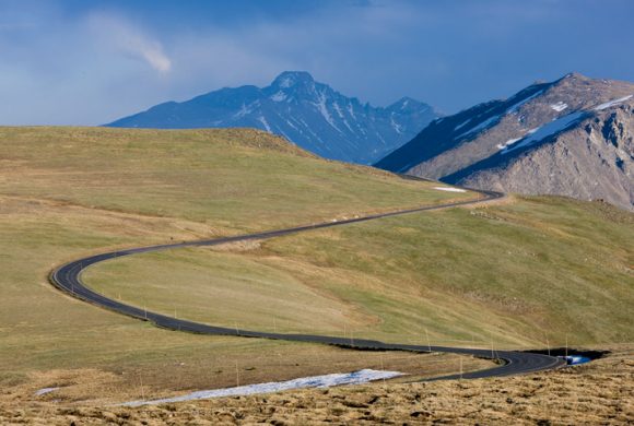
Covering the 48 miles between Estes Park on the park’s east side and Grand Lake on the west, Trail Ridge Road more than lives up to its advanced billing. Eleven miles of this high highway travel above treeline, the elevation near 11,500 feet where the park’s evergreen forests come to a halt. As it winds across the tundra’s vastness to its high point at 12,183 feet elevation, Trail Ridge Road (U.S. 34) offers visitors thrilling views, wildlife sightings and spectacular alpine wildflower exhibitions, all from the comfort of their car.
Whether they begin their journey at Estes Park or Grand Lake, Trail Ridge Road travelers climb some 4,000 feet in a matter of minutes. The changes that occur en route are fascinating to observe. A drive that may begin in montane forests of aspen and ponderosa pine soon enters thick subalpine forests of fir and spruce. At treeline, the last stunted, wind-battered trees yield to the alpine tundra.
Up on that windswept alpine world, conditions resemble those found in the Canadian or Alaskan Arctic. It’s normally windy and 20 to 30 degrees colder than Estes Park or Grand Lake. The sun beats down with high- ultraviolet intensity. The vistas, best enjoyed from one of several marked road pullovers, are extravagant, sweeping north to Wyoming, east across the Front Range cities and Great Plains, south and west into the heart of the Rockies.
But for all its harshness, the Trail Ridge tundra is a place of vibrant life and vivid colors. Pikas, marmots, ptarmigans and bighorn sheep are commonly seen. About 200 species of tiny alpine plants hug the ground. Despite a growing season that may last just 40 days, many bloom exuberantly, adorning the green summer tundra with swatches of yellow, red, pink, blue, purple and white. All are seen from the Tundra World Nature Trail, a half-hour walk beginning near the parking area at Rock Cut.
Most Trail Ridge Road travelers drive to treeline with a certain amount of urgency. They are advised not to ignore all that awaits in the verdant country below the alpine tundra. Forested moraines, great heaps of earth and rock debris left behind by melting Ice Age glaciers, rise above lush mountain meadows. The Continental Divide, where streamflows are separated east from west, is crossed at Milner Pass, located at a surprisingly low 10,120 feet elevation. Moose munch greenery in the upper reaches of the Colorado River, which flows through the scenic Kawuneeche Valley. Grazing elk greet sunrise and sunset in many of the forest-rimmed meadows found around the park.
At all elevations, the drive on Trail Ridge Road is a memorable adventure. Put aside at least a half day for the trip. Longer, if possible. The experience, as Horace Albright suggested more than a half century ago, is hard to describe.
Trail Ridge Road is one of ten America’s Byways in Colorado and a national designated All American Road. Like to see as many byways as you can? On the outskirts of Rocky is the oldest Colorado Scenic Byway, Peak to Peak, and another America’s Byway, the Colorado River Headwaters.


